

Intervals up to 121.2m of continuous visual copper mineralization intersected
HIGHLIGHTS
The excellent productivity for the 2024 summer drilling program continues with more than 8,300 metres ("m") now completed in 66 reverse circulation ("RC") and diamond drill holes
Visual results have been received for a further 22 drill holes, with the first assays for the summer program due within the next 2 weeks
Thunder Prospect - 2023 discovery hole 48.8m @ 3% copper ("Cu") from 32.4m:
Thick zones of visual copper mineralization have been intersected in all nine step-out drill holes at the Thunder Prospect, extending the known strike of the Thunder mineralization to over 300m and highlighting the potential for resource definition
Drill hole SR24-042 has intersected a continuous 73.2m thick zone of visual copper sulfide mineralization from 45.7m downhole including multiple zones of semi-massive sulfides
Drill hole SR24-034 has intersected a continuous 121.2m interval of visual copper sulfide mineralization from 18.3m downhole
The high-grade copper zone at Thunder remains open along strike and at depth, where drilling has only tested to approximately 100m vertical depth
Cyclone Prospect
Thick intervals of visual copper sulfides intersected in multiple drill holes, including several outside of the known zone of mineralization supporting the potential for growth and delineation of a future resource
Drill holes SR24-031 and SR-055 were drilled to the north-east of the Cyclone Prospect and have successfully expanded the strike of mineralization with intersections of 53.4m (combined total) and 80.7m (continuous)of visual copper mineralization respectively
Drill holes SR24-045 and SR24-049 have intersected thick intervals of visual semi-massive sulfides within the southern and western part of the mineralized zone
Visual estimates of mineral abundance should never be considered a proxy or substitute for laboratory analyses where concentrations or grades are the factor of principal economic interest. Laboratory assays are required to determine the presence and grade of any contained mineralization within the reported visual intersections of copper sulfides. Portable XRF is used as an aid in the determination of mineral type and abundance during the geological logging process.
TORONTO, ON / ACCESSWIRE / July 24, 2024 / Aston Bay Holdings Ltd. (TSXV:BAY)(OTCQB:ATBHF) ("Aston Bay" or the "Company") is pleased to present an update on drilling and exploration activities currently underway at the Storm Copper Project ("Storm" or the "Project") on Somerset Island, Nunavut. The program is being conducted by American West Metals Limited ("American West"), who is the operator of the Project. Aston Bay and American West have formed a 20/80 unincorporated joint venture in respect of the Storm Project property, with Aston Bay maintaining a free carried interest until a decision to mine upon completion of a bankable feasibility study.
Thomas Ullrich, Chief Executive Officer of Aston Bay, commented :
"The impressive visual results continue to come in from the drilling at Storm, highlighting the significant potential for growth and delineation of a potential future resource at the project as well as additional discoveries.
"Equally impressive are the efforts of the entire crew of drillers, geologists, geophysicists, pilots and camp support staff - we thank them for delivering results and credit them all for the success of the ongoing program."
OVERVIEW: DRILL PROGRAM ON TARGET TO EXCEED 20,000 METRES
A total of 60 RC drill holes (for approximately 7,660m) have now been completed during the 2024 drilling program. The diamond drill rig has completed 6 drill holes (for approximately 677m).
The latest drilling has been completed at the Cyclone, Chinook, Thunder, and Lightning Ridge high-grade copper prospects, and on various exploration targets within Storm. The visual results from 22 of these drill holes have been received. The mineralogy and presence of copper have been confirmed with portable XRF analysis.
The 2024 drill program is continuing with two RC and one diamond drill rig. The excellent production of the drilling achieved to date puts the program on track to complete the planned 20,000m of drilling.
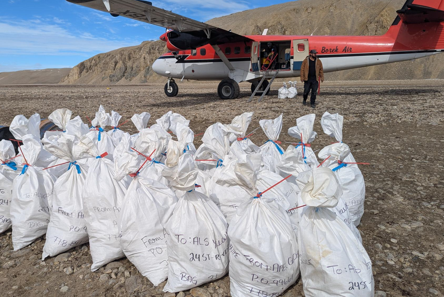
Figure 1: Reverse Circulation (RC) drill samples at the Storm Project, Nunavut, being loaded for their journey to the laboratory in Yellowknife for processing.
THUNDER COPPER PROSPECT: MINERALIZATION EXTENDED OVER 300M, OPEN IN ALL DIRECTIONS
The Thunder Prospect is located to the west of the Chinook and Lightning Ridge copper prospects. The high-grade copper zone was discovered with exploration drilling during 2023 in which drill hole ST23-03 intersected 48.8m @ 3% Cu from 32m downhole.
The discovery drill hole at Thunder was designed to test a strong EM anomaly in the vicinity of historical drilling which had intersected thin zones of high-grade copper sulfides (ST00-66 intersected 7.6M @ 1.6% Cu from 55.5m downhole, including 1.1m @ 4.8% Cu from 58.3m downhole).
The Thunder prospect is located within the extensive southern graben fault system, which hosts all known copper deposits in the southern area of Storm. The proximity of Thunder to a major fault jog and the high volume of semi-massive sulfide breccia mineralization is strongly suggestive that the copper is fault-related and steeply dipping, as seen at the nearby Chinook and Corona prospects.
The initial drilling during 2024 at Thunder has included nine widely spaced drill holes designed to test the strike extent and potential geometry of the high-grade mineralization intersected during 2023 (Figure 2 & 3).
The visual results have now been received and confirm that all drills holes have intersected visual copper sulfides, including thick intervals of very strong visual copper sulfides within the interpreted main zone of mineralization The known strike extent of the Thunder copper zone is now interpreted to be over 300m, and it remains open along strike and at depth.
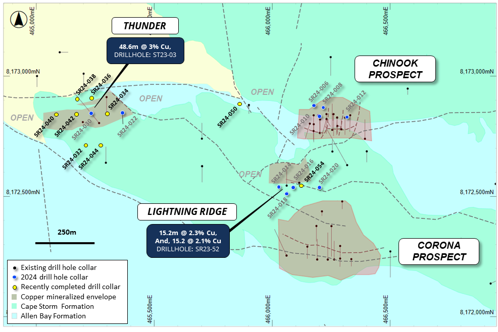
Figure 2: Plan view of the Chinook, Corona, Thunder, and Lightning Ridge areas showing the interpreted footprints of the near-surface copper mineralization (defined by drilling, MLEM and VTEM) and drilling overlaying regional geology.
THUNDER MAIN COPPER ZONE DRILL HOLE DETAILS
RC drill holes SR24-022, -030, -034, -040, and -042 were drilled along the interpreted east-west strike of the Thunder mineralized zone (Figure 2).
Drill holes SR24-030, -034, and -042 have intersected thick visual copper sulfide mineralization (approximately 58.5m, 121.9m, and 73.2m respectively). The mineralization within these drill holes is dominantly chalcocite and particularly strong in the vicinity and to the west of discovery drill hole ST23-03.
Drill hole SR24-040 is the westernmost drill hole completed to date at the Thunder Prospect. The drill hole intersected 36.6m of visual chalcocite mineralization from approximately 47.2m downhole, which contains a zone of over 5% visual sulfide at approximately 70.1m downhole. The wide interval and strong nature of the mineralization within SR24-040 suggest that the copper mineralization will likely extend further to the west.
Drill hole SR24-022 was drilled approximately 130m to the east of the main zone and intersected two intervals of minor chalcocite, chalcopyrite, and pyrite mineralization. The drill hole was drilled oriented to the south and missed the main zone of mineralization. The chalcopyrite-pyrite mineral assemblage intersected in the lower interval is typical of the margins of sediment-hosted copper systems. Further drilling is planned to determine the extent and location of the Thunder mineralization in this area.
Mineralization key: cc = chalcocite, cp = chalcopyrite, br = bornite, py = pyrite, Cu = native copper, ct = cuprite, ml = malachite, sph = sphalerite, ga = galena. (5%) = visual estimation of sulfide content.
Hole ID |
From (m) |
To (m) |
Min |
Description |
SR24-022 |
0 |
33.5 |
|
Cape Storm Formation |
|
33.5 |
35.1 |
|
Allen Bay Formation |
|
35.1 |
38.1 |
cc, ma |
Veins of cc with patchy py (0.2%) |
|
38.1 |
62.5 |
|
Allen Bay dolomudstones |
|
62.5 |
67.1 |
py, cp |
Patchy cp (0.1%) |
|
67.1 |
86.9 |
py |
Patchy py (0.1%) |
|
86.9 |
140.2 |
|
Allen Bay dolomudstone |
SR24-030 |
0 |
24.38 |
|
Cape Storm Formation |
|
24.4 |
35.1 |
py |
py veins (up to 0.5%) |
|
35.1 |
74.7 |
cc, bn, py, cp, cu |
Vein with up to 5% cc, up to 1% bn, 0.5% cp, patchy py (0.2%) |
|
74.7 |
77.7 |
|
Allen Bay Fm. Dolomudstone |
|
77.7 |
115.8 |
bn, cc, cp, py |
Veins up to 0.5% bn, 0.1% cp, up to 1.5% cc and 0.2% py |
|
115.8 |
118.9 |
cc |
Breccia/vein cc (7.5%) |
|
118.9 |
125 |
cc, cp, py |
1% patchy cc and 0.1% patchy bn and cp |
SR24-034 |
0 |
18.3 |
|
Allen Bay Formation |
|
18.3 |
68.6 |
py, cp |
Intermittent cp and py (0.1%) |
|
68.6 |
115.8 |
py, cp |
Mostly cp with cc veinlets (0.5%) |
|
115.8 |
140.2 |
py, cp |
Cp mineralization decreasing with depth (0.2%) |
SR24-040 |
0 |
47.2 |
|
Cape Storm Formation |
|
47.2 |
83.8 |
cu, cc |
cc veins and breccia throughout, 5% cc at 70.1m |
|
83.8 |
123.4 |
|
Allen Bay dolomudstone |
|
123.4 |
129.5 |
|
Allen Bay dolomudstone |
SR24-042 |
0 |
39.6 |
|
Cape Storm Formation |
|
39.6 |
45.7 |
|
Allen Bay Formation |
|
45.7 |
80.8 |
cc |
Breccia cc (3-5%) |
|
80.8 |
118.9 |
cc |
Breccia cc (1-2%) |
|
118.9 |
140.2 |
|
Allen Bay Formation |
Table 1: Summary geological logs for drill holes SR24-022, -030, -034, -040, and -042.
Visual estimates of mineral abundance should never be considered a proxy or substitute for laboratory analyses where concentrations or grades are the factor of principal economic interest. Laboratory assays are required to determine the presence and grade of any contained mineralization within the reported visual intersections of copper sulfides. Portable XRF is used as an aid in the determination of mineral type and abundance during the geological logging process.
THUNDER EXPLORATION DRILL HOLE DETAILS
Four RC drill holes were drilled around the interpreted Thunder trend to determine the orientation of the high-grade copper mineralization.
Drill holes SR24-036 and SR24-038 were drilled to the north of the prospect, and were designed to test the potential lateral extension of the mineralization to the north. Both drill holes intersected thick intervals of visual copper sulfides (41.2m and 38.1m respectively). The dominant visual copper sulfide in both drill holes is chalcopyrite, with chalcocite also encountered in SR24-038.
Drill holes SR24-032 and SR24-044 are located approximately 150m south of the interpreted Thunder mineralized zone, and were drilled toward the north. This orientation was designed to test both the vertical and potential southern lateral extent of the mineralization. Both drill holes intersected thick intervals of visual copper sulfides (38.1m and 39.2m respectively), including very strong visual chalcocite mineralization in drill hole SR24-044 at approximately 86.9 - 90m downhole.
The visual copper sulfides within all of the Thunder drill holes are hosted in veinlets and breccias within the Allen Bay dolomudstones. However, the assemblage of copper minerals in the southern and northern Thunder drill holes (including abundant chalcopyrite and pyrite) suggests that they are potentially located on the margin of an east-west orientated and steeply dipping copper system. Diamond drilling is planned to confirm these assumptions.
Mineralization key for the tables below: cc = chalcocite, cp = chalcopyrite, br = bornite, py = pyrite, Cu = native copper, ct = cuprite, ml = malachite, sph = sphalerite, ga = galena. (5%) = visual estimation of sulfide content
Hole ID |
From (m) |
To (m) |
Min |
Description |
SR24-036 |
0 |
35.1 |
|
Cape Storm Formation |
|
35.1 |
76.2 |
py, cp |
Patchy cc and py (0.1%) |
|
76.2 |
123.4 |
|
Allen Bay Formation |
|
123.4 |
140.2 |
|
Patchy py (0.1%) |
SR24-038 |
0 |
39.6 |
|
Cape Storm Formation, trace ma (0.1%) |
|
39.6 |
77.7 |
cc, cp |
Trace cc and cp (0.2%) |
|
77.7 |
117.4 |
|
Allen Bay Formation, dark brown |
|
117.4 |
140.2 |
|
Allen Bay Formation |
Table 2: Summary geological logs for drill hole SR24-036 and SR24-038.
Visual estimates of mineral abundance should never be considered a proxy or substitute for laboratory analyses where concentrations or grades are the factor of principal economic interest. Laboratory assays are required to determine the presence and grade of any contained mineralization within the reported visual intersections of copper sulfides. Portable XRF is used as an aid in the determination of mineral type and abundance during the geological logging process.
Hole ID |
From (m) |
To (m) |
Min |
Description |
SR24-032 |
0 |
13.7 |
|
Overburden |
|
13.72 |
62.5 |
|
Allen Bay Formation |
|
62.5 |
100.6 |
cp |
Cp veins (0.1%), more abundant 76.2-88.4m (1%) |
|
100.6 |
199.6 |
|
Allen Bay dolomudstone |
SR24-044 |
0 |
22.9 |
|
Cape Storm Formation |
|
22.9 |
67.1 |
|
Allen Bay Formation |
|
67.1 |
106.7 |
cc |
Cc veins (0.5%), more abundant 86.9-89.9m (2%) |
|
106.7 |
135.6 |
|
Allen Bay - BFP |
|
135.6 |
155.5 |
|
Allen Bay dolomudstones |
|
155.5 |
167.6 |
|
Allen Bay dolomudstones, trace chert nodules |
Table 3: Summary geological logs for drill hole SR24-032 and SR24-044.
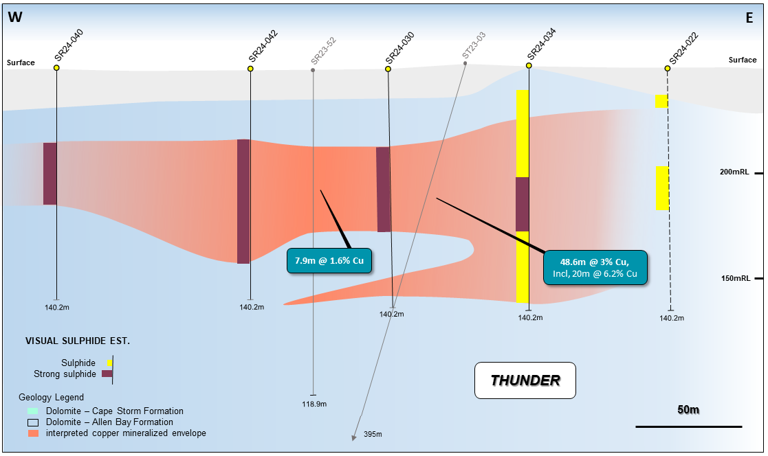
Figure 3: Geological long-section view (looking north) at 8,172,830N showing the visual results of drill holes for the main zone drilling at Thunder, historical drilling, and the interpreted copper horizons. Note - SR24-022 is interpreted to be off-section to the main mineralized trend (dotted).
CYCLONE: MORE THICK COPPER INTERSECTIONS
Drilling at the Cyclone Prospect is continuing and the visual results from drill holes SR24-028, -029, -031, -035, -037, -039, -043, -045, -047, -049, -051, -053, -055 have been received.
The visual results continue to demonstrate the excellent lateral continuity of the copper mineralization and confirm the potential for future resources at Cyclone and to the southwest, east, and north.
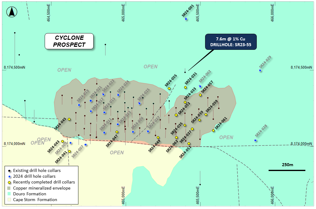
Figure 4: Plan view of the Cyclone Prospect showing the interpreted outline of copper mineralization, historical and recent drilling, overlaying regional geology.
DRILL HOLE SR24-031 & SR24-055 DETAILS
Drill holes SR24-031 and SR24-055 were drilled to the northeast of the Cyclone Prospect. The drill holes are located within a large and untested area and were designed to test for potential extensions to the known copper mineralization to the north of Cyclone, and between 2023 drill hole SR23-55 (7.6m @ 1% Cu from 105.2m downhole, including 1.5m @ 2% Cu from 109.7m downhole) (Figure 4).
SR24-031 has intersected a combined total of 53.4m of visual copper sulfide mineralization within two distinct zones (Figure 5). The visual mineralization is vertically zoned with a chalcocite dominant inner and stronger zone (between 96m and 121.9m downhole), and with chalcopyrite mineralization at the margins at the top and bottom of the interval. This zonation of copper minerals is typical of sediment-hosted copper systems. The interval contains a 1.5m thick zone of very strong chalcocite veining from 109.7m downhole.
SR24-055 has intersected 80.7m of visual copper mineralization from 48.8m downhole consisting of fine chalcocite veinlets and breccias. The volume of visual sulfide mineralization within the extremely thick interval of mineralization is largely consistent at 0.2% to 0.5% but does contain numerous zones with stronger veining. Minor chalcopyrite is also present in the top 39.6m of the interval.

Figure 5: Geological section view at 465,400E showing the visual results for drill holes SR24-031 and SR24-035, and the existing interpreted copper mineralized zone.
Visual estimates of mineral abundance should never be considered a proxy or substitute for laboratory analyses where concentrations or grades are the factor of principal economic interest. Laboratory assays are required to determine the presence and grade of any contained mineralization within the reported visual intersections of copper sulfides. Portable XRF is used as an aid in the determination of mineral type and abundance during the geological logging process.
Hole ID |
From (m) |
To (m) |
Min |
Description |
SR24-031 |
0 |
22.9 |
|
Cape Storm Formation |
|
22.9 |
50.3 |
|
Allen Bay Fm. Dolomudstone |
|
50.3 |
56.4 |
py, cp |
Patchy cp (0.1%) and py (0.1%) |
|
56.4 |
65.5 |
|
Allen Bay Fm. Dolomudstone |
|
65.5 |
80.8 |
ma, py |
Trace vein selvage py (0.1%), ma (0.1%) |
|
80.8 |
85.3 |
|
Allen Bay Fm. Dolomudstone |
|
85.3 |
96 |
cp, py |
Patchy cp (0.1%) and py (0.1%) |
|
96 |
109.7 |
cc, py, bn |
cc vein and patchy py, with trace bn (0.2%) |
|
109.7 |
111.3 |
cc, py |
cc veins and vein selvage 2% |
|
111.3 |
121.9 |
cp, py, cc |
cc and cp vein selvage, patchy py (0.2%) |
|
121.9 |
132.6 |
py, cp |
Patchy intermittent py (0.1%) |
|
132.6 |
150.9 |
|
Allen Bay Fm. Dolomudstone |
SR24-055 |
0 |
48.8 |
|
Cape Storm Formation |
|
48.8 |
88.4 |
cc, cp |
Fe alt with cc and cp (0.5%) |
|
88.4 |
126.5 |
cc |
Trace cc (0.2%) |
|
126.5 |
170.7 |
|
Allen Bay Formation |
Table 4: Summary geological logs for drill holes SR24-031 and SR24-055.
DRILL HOLE SR24-043 DETAILS
SR24-043 was drilled approximately 80m southwest of the Cyclone Prospect to a downhole depth of 160m. The drill hole was designed to test for potential extensions to the known areas of copper mineralization and to follow up to the west of 2024 drill hole SR24-009.
SR24-043 has intersected a single, 16.8m thick upper zone of visual copper sulfide mineralization, and a lower zone of copper oxides. The upper chalcopyrite-dominant zone of mineralization is strongly mineralized and also contains chalcocite between 91.4m and 96m downhole.
The large step out and thickness of the strong visual mineralization suggests the potential for significant extension to Cyclone to the southwest.
Visual estimates of mineral abundance should never be considered a proxy or substitute for laboratory analyses where concentrations or grades are the factor of principal economic interest. Laboratory assays are required to determine the presence and grade of any contained mineralization within the reported visual intersections of copper sulfides. Portable XRF is used as an aid in the determination of mineral type and abundance during the geological logging process.
Hole ID |
From (m) |
To (m) |
Min |
Description |
SR24-035 |
0.0 |
12.2 |
ma |
Cape Storm - patchy ma (0.1%) near top of hole |
|
12.2 |
18.3 |
py |
Cape Storm - patchy py (0.1%) |
|
18.3 |
32.0 |
py, ma |
py (0.1%) vein selvage and veinlets, ma (0.1%) |
|
32.0 |
36.6 |
py |
Patchy py (0.1%) |
|
36.6 |
44.2 |
py, cp |
Patchy py (0.1%) and cp (0.2%) |
|
44.2 |
48.8 |
ma, py |
Trace patchy py and ma (0.1%) |
|
48.8 |
50.3 |
cc, cu |
Trace cc and native Cu (0.1%) |
|
50.3 |
54.9 |
py, ma, cc, cu |
Trace py, ma, cc (0.1%) and native Cu (0.1%) |
|
54.9 |
57.9 |
|
Allen Bay Fm. Dolomudstone |
|
57.9 |
61.0 |
cc |
cc vein selvage and veins (2%) |
|
61.0 |
67.1 |
|
Allen Bay fm. Dolomudstone |
|
67.1 |
76.2 |
ma, cc, cuox |
Up to 5% ma, trace cc (0.1%) and CuOx (0.1%) |
|
76.2 |
97.5 |
|
Allen Bay Fm. Dolomudstone |
|
91.4 |
120.4 |
ma |
Allen Bay Fm. Dolomudstone with ma (0.1%) |
SR24-037 |
0.0 |
12.2 |
|
Cape Storm Formation |
|
12.2 |
16.8 |
|
Allen Bay Fm. Dolomudstone |
|
16.8 |
25.9 |
py |
Patchy to vein selvage py (0.1%) |
|
25.9 |
33.5 |
|
Allen Bay Fm. Dolomudstone |
|
33.5 |
38.1 |
py |
Trace patchy py (0.1%) |
|
38.1 |
44.2 |
|
Allen Bay Fm. Dolomudstone |
|
44.2 |
50.3 |
py |
Trace patchy py (0.1%) |
|
50.3 |
54.9 |
py, cc, cp |
cc (0.5%) vein, patchy cp (0.1%) and py (0.1%) |
|
54.9 |
61.0 |
py, cc |
Intermittent cc (0.5%) vein and patchy py (0.1%) |
|
61.0 |
65.5 |
|
Allen Bay Fm. Dolomudstone |
|
65.5 |
67.1 |
cc |
Trace cc (0.1%) vein selvage |
|
67.1 |
73.2 |
|
Allen Bay Fm. Dolomudstone with clay at 68.6m' |
|
73.2 |
74.7 |
cc, ma |
Trace cc (0.1%) vein selvage, patchy ma |
|
74.7 |
99.1 |
|
Allen Bay Fm. with clay at 79.4m, 88.4m |
SR24-039 |
0.0 |
15.2 |
|
Cape Storm Formation |
|
15.2 |
24.4 |
|
Allen Bay Fm. Dolomudstone |
|
24.4 |
30.5 |
py |
Trace patchy and vein selvage py (0.1%) |
|
30.5 |
39.6 |
|
Allen Bay Fm. Dolomudstone |
|
39.6 |
44.2 |
py |
Trace patchy and vein selvage py (0.1%) |
|
44.2 |
47.2 |
|
Allen Bay Fm. Dolomudstone |
|
47.2 |
51.8 |
py, cp |
cp veinlets (0.3%) and patchy and vein py (0.1%) |
|
51.8 |
64.0 |
py |
Intermittent trace py (0.1%) |
|
64.0 |
83.8 |
|
Allen Bay Formation |
|
83.8 |
86.9 |
cc, py |
0.5% cc vein selvage and trace py (0.1%) |
|
86.9 |
115.8 |
|
Allen Bay Fm. Dolomudstone - BPF |
|
115.8 |
129.5 |
|
Allen Bay Fm. Dolomudstone - VSM |
SR24-045 |
0.0 |
29.0 |
cp |
Cape Storm F.5mormation with cp (0.1%) |
|
29.0 |
65.5 |
cp, cc |
Patchy cc and cp (0.2%) with 5% cc at 57.9m |
|
65.5 |
71.6 |
cp, cc |
Breccia cp and cc (5%) with 8% at 65 |
|
71.6 |
79.3 |
cc |
Vein and breccia cc (3%) |
|
79.3 |
108.2 |
cc |
Vein and breccia cc (1%) with 4% at 88.4m |
|
108.2 |
160.0 |
|
Allen Bay Formation |
SR24-047 |
0.0 |
18.3 |
|
Cape Storm Formation |
|
18.3 |
36.6 |
|
Allen Bay Formation |
|
36.6 |
41.2 |
|
Clay zone, poor recovery |
|
41.2 |
59.4 |
cc, cp |
Trace cc and cp (0.1%) |
|
59.4 |
89.9 |
cc, cp, cu |
Cc and cp (1%) with trace ma |
|
89.9 |
111.3 |
|
Allen Bay Formation |
SR24-049 |
0.0 |
13.7 |
|
Cape Storm Formation, trace malachite |
|
13.7 |
32.0 |
cc, py |
Weak Fe alt, cc veins (0.2%) |
|
32.0 |
35.1 |
cc, py |
High cc sulfide content (5%) |
|
35.1 |
50.3 |
cc, py |
Patchy cc and py (0.2%) |
|
50.3 |
74.7 |
cc, py |
BMF, Patchy cc and py (0.2%) |
|
74.7 |
96.0 |
|
Allen Bay Formation |
SR24-051 |
0.0 |
100.6 |
py |
Douro Formation with trace py (0.1%) |
SR24-053 |
0.0 |
33.5 |
|
Cape Storm Formation, trace malachite. |
|
33.5 |
53.3 |
cc |
Cc (0.2%) and trace malachite |
|
53.3 |
57.9 |
cc, py |
High sulfide content (1%) |
|
57.9 |
86.9 |
cc, py |
Trace cc and py (0.2%) |
|
86.9 |
117.4 |
|
Allen Bay Formation, trace malachite. |
|
117.4 |
129.5 |
|
Allen Bay Formation with minor chalk |
Table 5: Summary geological log for drill hole SR24-043.
DRILL HOLE SR24-028 & SR24-029 DETAILS
Drill holes SR24-028 and SR24-029 were drilled over 300m to the east of Cyclone. The drill holes were designed to test for large potential resource extensions along the northern graben fault.
Neither of the drill holes intersected significant intervals of copper sulfide mineralization, and the presence of pyrite suggests that the drill holes may be located on the margin of the mineral system.
MAIN CYCLONE ZONE DRILLING
Drill holes SR24-035, -037, -039, -045, -047, -049, -051, and -053 were drilled to infill areas of known mineralization in support of a potential future mineral resource. All but one of the drill holes have intersected thick intervals of visual copper sulfide mineralization hosted within dolomite of the Allen Bay Formation.
The mineralization encountered within the drilling to date is comprised of zones of strong visual sulfides hosted within a broad mineralized package of what is interpreted to be mostly vein and fracture-style mineralization. Zones of visually strong, semi-massive copper sulfides were observed in drill holes SR24-045 and SR45-049.
Drill hole SR-051 was drilled to a downhole depth of 100.6m encountering only trace pyrite and is interpreted to have been drilled south of the large structure that offsets Cyclone deposit. The entire length of the drill hole intersected the Douro Formation, which is the common unmineralized rock unit found on the top of the mineralization-hosting Allen Bay Formation in the downthrown block of the Central Graben Area. Deeper drilling is required in this area to determine the depth of the prospective copper horizon, and for potential off-sets to the Cyclone Prospect.
The dominant visible copper sulfide minerals observed within the Cyclone drill holes to date are chalcocite with minor bornite and with chalcopyrite on the margins of the mineralized intervals. Minor native copper and copper oxides (mostly malachite and cuprite) are also locally present. Portable XRF analyzers are used to assist the geological logging.
Visual estimates of mineral abundance should never be considered a proxy or substitute for laboratory analyses where concentrations or grades are the factor of principal economic interest. Laboratory assays are required to determine the presence and grade of any contained mineralization within the reported visual intersections of copper sulfides. Portable XRF is used as an aid in the determination of mineral type and abundance during the geological logging process.
Hole ID |
From (m) |
To (m) |
Min |
Description |
SR24-035 |
0.0 |
12.2 |
ma |
Cape Storm - patchy ma (0.1%) near top of hole |
|
12.2 |
18.3 |
py |
Cape Storm - patchy py (0.1%) |
|
18.3 |
32.0 |
py, ma |
py (0.1%) vein selvage and veinlets, ma (0.1%) |
|
32.0 |
36.6 |
py |
Patchy py (0.1%) |
|
36.6 |
44.2 |
py, cp |
Patchy py (0.1%) and cp (0.2%) |
|
44.2 |
48.8 |
ma, py |
Trace patchy py and ma (0.1%) |
|
48.8 |
50.3 |
cc, cu |
Trace cc and native Cu (0.1%) |
|
50.3 |
54.9 |
py, ma, cc, cu |
Trace py, ma, cc (0.1%) and native Cu (0.1%) |
|
54.9 |
57.9 |
|
Allen Bay Fm. Dolomudstone |
|
57.9 |
61.0 |
cc |
cc vein selvage and veins (2%) |
|
61.0 |
67.1 |
|
Allen Bay fm. Dolomudstone |
|
67.1 |
76.2 |
ma, cc, cuox |
Up to 5% ma, trace cc (0.1%) and CuOx (0.1%) |
|
76.2 |
97.5 |
|
Allen Bay Fm. Dolomudstone |
|
91.4 |
120.4 |
ma |
Allen Bay Fm. Dolomudstone with ma (0.1%) |
SR24-037 |
0.0 |
12.2 |
|
Cape Storm Formation |
|
12.2 |
16.8 |
|
Allen Bay Fm. Dolomudstone |
|
16.8 |
25.9 |
py |
Patchy to vein selvage py (0.1%) |
|
25.9 |
33.5 |
|
Allen Bay Fm. Dolomudstone |
|
33.5 |
38.1 |
py |
Trace patchy py (0.1%) |
|
38.1 |
44.2 |
|
Allen Bay Fm. Dolomudstone |
|
44.2 |
50.3 |
py |
Trace patchy py (0.1%) |
|
50.3 |
54.9 |
py, cc, cp |
cc (0.5%) vein, patchy cp (0.1%) and py (0.1%) |
|
54.9 |
61.0 |
py, cc |
Intermittent cc (0.5%) vein and patchy py (0.1%) |
|
61.0 |
65.5 |
|
Allen Bay Fm. Dolomudstone |
|
65.5 |
67.1 |
cc |
Trace cc (0.1%) vein selvage |
|
67.1 |
73.2 |
|
Allen Bay Fm. Dolomudstone with clay at 68.6m' |
|
73.2 |
74.7 |
cc, ma |
Trace cc (0.1%) vein selvage, patchy ma |
|
74.7 |
99.1 |
|
Allen Bay Fm. with clay at 79.4m, 88.4m |
SR24-039 |
0.0 |
15.2 |
|
Cape Storm Formation |
|
15.2 |
24.4 |
|
Allen Bay Fm. Dolomudstone |
|
24.4 |
30.5 |
py |
Trace patchy and vein selvage py (0.1%) |
|
30.5 |
39.6 |
|
Allen Bay Fm. Dolomudstone |
|
39.6 |
44.2 |
py |
Trace patchy and vein selvage py (0.1%) |
|
44.2 |
47.2 |
|
Allen Bay Fm. Dolomudstone |
|
47.2 |
51.8 |
py, cp |
cp veinlets (0.3%) and patchy and vein py (0.1%) |
|
51.8 |
64.0 |
py |
Intermittent trace py (0.1%) |
|
64.0 |
83.8 |
|
Allen Bay Formation |
|
83.8 |
86.9 |
cc, py |
0.5% cc vein selvage and trace py (0.1%) |
|
86.9 |
115.8 |
|
Allen Bay Fm. Dolomudstone - BPF |
|
115.8 |
129.5 |
|
Allen Bay Fm. Dolomudstone - VSM |
SR24-045 |
0.0 |
29.0 |
cp |
Cape Storm F.5mormation with cp (0.1%) |
|
29.0 |
65.5 |
cp, cc |
Patchy cc and cp (0.2%) with 5% cc at 57.9m |
|
65.5 |
71.6 |
cp, cc |
Breccia cp and cc (5%) with 8% at 65 |
|
71.6 |
79.3 |
cc |
Vein and breccia cc (3%) |
|
79.3 |
108.2 |
cc |
Vein and breccia cc (1%) with 4% at 88.4m |
|
108.2 |
160.0 |
|
Allen Bay Formation |
SR24-047 |
0.0 |
18.3 |
|
Cape Storm Formation |
|
18.3 |
36.6 |
|
Allen Bay Formation |
|
36.6 |
41.2 |
|
Clay zone, poor recovery |
|
41.2 |
59.4 |
cc, cp |
Trace cc and cp (0.1%) |
|
59.4 |
89.9 |
cc, cp, cu |
Cc and cp (1%) with trace ma |
|
89.9 |
111.3 |
|
Allen Bay Formation |
SR24-049 |
0.0 |
13.7 |
|
Cape Storm Formation, trace malachite |
|
13.7 |
32.0 |
cc, py |
Weak Fe alt, cc veins (0.2%) |
|
32.0 |
35.1 |
cc, py |
High cc sulfide content (5%) |
|
35.1 |
50.3 |
cc, py |
Patchy cc and py (0.2%) |
|
50.3 |
74.7 |
cc, py |
BMF, Patchy cc and py (0.2%) |
|
74.7 |
96.0 |
|
Allen Bay Formation |
SR24-051 |
0.0 |
100.6 |
py |
Douro Formation with trace py (0.1%) |
SR24-053 |
0.0 |
33.5 |
|
Cape Storm Formation, trace malachite. |
|
33.5 |
53.3 |
cc |
Cc (0.2%) and trace malachite |
|
53.3 |
57.9 |
cc, py |
High sulfide content (1%) |
|
57.9 |
86.9 |
cc, py |
Trace cc and py (0.2%) |
|
86.9 |
117.4 |
|
Allen Bay Formation, trace malachite. |
|
117.4 |
129.5 |
|
Allen Bay Formation with minor chalk |
Table 6: Summary geological logs for recently completed resource infill drill holes at the Cyclone Prospect.
Mineralization key: cc = chalcocite, cp = chalcopyrite, br = bornite, py = pyrite, Cu = native copper, ct = cuprite, ml = malachite, sph = sphalerite, ga = galena. (5%) = visual estimation of sulfide content.
DIAMOND DRILLING PROGRAM
Diamond drilling is underway and progressing rapidly at Storm. Six drill holes have been completed to date for a total of 667.7m drilled.
The initial drill holes are being used to acquire bulk samples for metallurgy, geotechnical and development planning purposes at the Cyclone and Chinook Prospects. The relatively shallow drill holes are infilling specific areas of the known footprint of copper mineralization and will also be used in support of a potential mineral resource.
Exploration drilling is due to begin with the diamond rig shortly. The initial priority will be to follow-up the discovery of high-grade copper sulfide mineralization at a deeper stratigraphic level below the Cyclone horizon.
The deep exploration targets will be further refined by the upcoming Moving Loop EM (MLEM) survey, commencing in the next few days, prior to drilling.
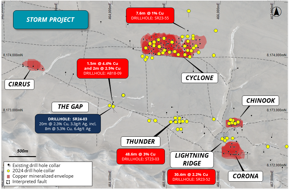
Figure 6: Recent and existing drill hole locations and inferred zones of copper mineralization overlaying aerial photography.
Hole ID |
Prospect |
Easting |
Northing |
Depth (m) |
Azimuth |
Inclination |
SR24-001 |
Expl. |
465403 |
8174839 |
251.5 |
180 |
-75 |
SR24-002 |
Cyclone |
465497 |
8174396 |
140.2 |
180 |
-70 |
SR24-003 |
The Gap |
464015 |
8173152 |
149.4 |
170 |
-45 |
SR24-004 |
The Gap |
463975 |
8173143 |
199.6 |
130 |
-60 |
SR24-005 |
Graben |
464200 |
8173324 |
251.5 |
180 |
-75 |
SR24-006 |
Chinook |
466176 |
8172877 |
129.5 |
180 |
-60 |
SR24-007 |
Cyclone |
464729 |
8174010 |
150.9 |
0 |
-70 |
SR24-008 |
Chinook |
466216 |
8172870 |
140.2 |
180 |
-60 |
SR24-009 |
Cyclone |
464629 |
8174021 |
120.4 |
0 |
-70 |
SR24-010 |
Chinook |
466197 |
8172835 |
109.7 |
180 |
-60 |
SR24-011 |
Cyclone |
464855 |
8174089 |
131.1 |
180 |
-70 |
SR24-012 |
Chinook |
466317 |
8172830 |
115.8 |
180 |
-60 |
SR24-013 |
Cyclone |
464945 |
8174144 |
120.4 |
180 |
-70 |
SR24-014 |
Lightning |
466029 |
8172538 |
118.9 |
0 |
-50 |
SR24-015 |
Cyclone |
464856 |
8174223 |
160.0 |
180 |
-70 |
SR24-016 |
Lightning |
466091 |
8172538 |
129.5 |
0 |
-50 |
SR24-017 |
Cyclone |
464765 |
8174233 |
120.4 |
180 |
-70 |
SR24-018 |
Lightning |
466063 |
8172513 |
149.3 |
0 |
-50 |
SR24-019 |
Cyclone |
464688 |
8174273 |
121.9 |
180 |
-75 |
SR24-020 |
Lightning |
466201 |
8072538 |
140.2 |
0 |
-50 |
SR24-021 |
Cyclone |
464763 |
8174300 |
131.1 |
180 |
-70 |
SR24-022 |
Thunder |
465364 |
8172845 |
140.2 |
180 |
-60 |
SR24-023 |
Cyclone |
464848 |
8174344 |
144.8 |
180 |
-70 |
SR24-024 |
Cyclone |
464948 |
8174340 |
149.3 |
180 |
-61 |
SR24-025 |
Cyclone |
465089 |
8174285 |
170.7 |
180 |
-65 |
SR24-026 |
Cyclone |
465048 |
8174094 |
120.4 |
180 |
-70 |
SR24-027 |
Cyclone |
465147 |
8174100 |
114.3 |
180 |
-63 |
SR24-028 |
Expl. |
465867 |
8174040 |
140.2 |
180 |
-65 |
SR24-029 |
Expl. |
465900 |
8174500 |
251.4 |
180 |
-65 |
SR24-030 |
Thunder |
465234 |
8172845 |
140.2 |
180 |
-60 |
SR24-031 |
Cyclone |
465397 |
8174393 |
150.9 |
179.7 |
-65.4 |
SR24-032 |
Thunder |
465209 |
8172709 |
199.6 |
0.0 |
-60.0 |
SR24-033 |
Cyclone |
465397 |
8174293 |
141.7 |
179.7 |
-65.1 |
SR24-034 |
Thunder |
465299 |
8172845 |
140.2 |
182.9 |
-60.9 |
SR24-035 |
Cyclone |
465397 |
8174139 |
120.4 |
180.1 |
-66.1 |
SR24-036 |
Thunder |
465234 |
8172910 |
140.2 |
180.4 |
-60.0 |
SR24-037 |
Cyclone |
465446 |
8174119 |
99.1 |
179.8 |
-61.5 |
SR24-038 |
Thunder |
465169 |
8172910 |
140.2 |
177.1 |
-60.5 |
SR24-039 |
Cyclone |
465493 |
8174177 |
129.5 |
180.0 |
-62.0 |
SR24-040 |
Thunder |
465079 |
8172845 |
129.5 |
180.0 |
-60.0 |
SR24-041 |
Cyclone |
464626 |
8173970 |
167.6 |
359.9 |
-70.0 |
SR24-042 |
Thunder |
465169 |
8172845 |
140.2 |
180.0 |
-59.9 |
SR24-043 |
Cyclone |
464581 |
8174035 |
160.0 |
359.9 |
-70.1 |
SR24-044 |
Thunder |
465269 |
8172709 |
167.6 |
0.0 |
-60.1 |
SR24-045 |
Cyclone |
464625 |
8174180 |
160.0 |
180.1 |
-61.5 |
SR24-046 |
Thunder W |
464686 |
8172873 |
199.6 |
0.3 |
-60.0 |
SR24-047 |
Cyclone |
464945 |
8174097 |
111.3 |
180.1 |
-70.0 |
SR24-048 |
Thunder W |
464803 |
8172870 |
199.6 |
0.1 |
-60.1 |
SR24-049 |
Cyclone |
465219 |
8174060 |
96.0 |
179.8 |
-70.0 |
SR24-050 |
Chinook W |
465862 |
8172885 |
150.9 |
359.6 |
-60.3 |
SR24-051 |
Cyclone |
465423 |
8174020 |
100.6 |
179.9 |
-63.1 |
SR24-052 |
Lightning |
466029 |
8172538 |
150.9 |
335.1 |
-44.9 |
SR24-053 |
Cyclone |
465337 |
8174210 |
129.5 |
179.9 |
-61.9 |
SR24-054 |
Lightning |
466126 |
8172537 |
129.5 |
0.0 |
-50.1 |
SR24-055 |
Cyclone |
465291 |
8174383 |
170.7 |
179.9 |
-65.0 |
SR24-056 |
Corona E |
466834 |
8172386 |
150.9 |
0.2 |
-60.1 |
SR24-057 |
Cyclone |
465497 |
8174343 |
141.7 |
180.2 |
-65.0 |
SR24-058 |
Corona E |
467248 |
8172395 |
167.6 |
180.0 |
-60.4 |
SR24-059 |
Cyclone |
465538 |
8174215 |
149.4 |
180.3 |
-65.1 |
SR24-061 |
Cyclone |
465587 |
8174105 |
149.4 |
180 |
-65 |
SM24-01 |
Chinook |
466275 |
8172777 |
79.0 |
0 |
-65 |
SM24-01A |
Chinook |
466275 |
8172777 |
98.0 |
0 |
-65 |
SM24-02 |
Chinook |
466176 |
8172760 |
104.0 |
0 |
-60 |
SM24-02A |
Chinook |
466176 |
8172760 |
104.0 |
0 |
-60 |
SM24-03 |
Cyclone |
465044 |
8174208 |
152.0 |
180 |
-70 |
SM24-03A |
Cyclone |
465044 |
8174208 |
18.0 |
180 |
-70 |
Table 7: Details for the 2024 drill holes completed to date.
PLANNED PROGRAM
RC drilling is continuing with two drill rigs (track-mounted and helicopter-portable) within the Storm area testing expansion and high-priority geophysical targets.
Diamond drilling is in progress on exploration targets.
First laboratory assays for the summer drill program are expected within 2 weeks, with further assays due in another 4 to 6 weeks
EM surveys will recommence shortly to complete the deep-searching surveys within the immediate Storm area, then move to the Tornado and Blizzard copper prospect areas.
The environmental monitoring and survey activities for the 2024 program are underway.
Studies on beneficiation processing methods have been completed on a variety of mineralized material from the Cyclone and Chinook Prospects, with results to be released shortly.
Qualified Person
Michael Dufresne, M.Sc., P.Geol., P.Geo., is a qualified person as defined by National Instrument 43-101 and has reviewed and approved the scientific and technical information in this press release.
About the Storm Copper and Seal Zinc-Silver Projects, Nunavut
The Nunavut property consists of 173 contiguous mining claims covering an area of approximately 219,257 hectares on Somerset Island, Nunavut, Canada. The Storm Project comprises both the Storm Copper Project, a high-grade sediment-hosted copper discovery (intersections including 110m* @ 2.5% Cu from surface and 56.3* @ 3.1% Cu from 12.2m as well as the Seal Zinc Deposit (intersections including 14.4m* @ 10.6% Zn, 28.7g/t Ag from 51.8m and 22.3m* @ 23.0% Zn, 5.1g/t Ag from 101.5m). Additionally, there are numerous underexplored and undrilled targets within the 120-kilometre strike length of the mineralized trend, including the Tornado copper prospect where 10 grab samples yielded >1% Cu up to 32% Cu in gossans. The Nunavut property is now the subject of an 80/20 unincorporated joint venture with American West (see "Agreement with American West" below for more details).
Storm Discovery and Historical Work
High-grade copper mineralization was discovered at Storm in the mid-1990s by Cominco geologists conducting regional zinc exploration around their then-producing Polaris lead-zinc mine. A massive chalcocite boulder found in a tributary of the Aston River in 1996 was traced to impressive surface exposures of broken chalcocite mineralization for hundreds of metres of surface strike length at what became named the 2750N, 2200N, and 3500N zones. Subsequent seasons of prospecting, geophysics and over 9,000 m of drilling into the early 2000s confirmed a significant amount of copper mineralization below the surface exposures as well as making the blind discovery of the 4100N Zone, a large area of copper mineralization with no surface exposure.
Following the merger of Cominco with Teck in 2001 and the closure of the Polaris Mine, the Storm claims were allowed to lapse in 2007. Commander Resources staked the property in 2008 and flew a helicopter-borne VTEM survey in 2011 but conducted no additional drilling. Aston Bay subsequently entered into an earn-in agreement with Commander and consolidated 100% ownership in 2015. Commander retained a 0.875% Gross Overriding Royalty in the area of the original Storm claims which was purchased by Taurus Mining Royalty Fund L.P. in January 2024.
In 2016 Aston Bay entered into an earn-in agreement with BHP, who conducted a 2,000-station soil sampling program and drilled 1,951m of core in 12 diamond drill holes, yielding up to 16m* @ 3.1% Cu. BHP exited the agreement in 2017 and retains no residual interest in the project. Aston Bay conducted a property-wide airborne gravity gradiometry survey in 2017 and drilled 2,913m in nine core holes in the Storm area in 2018 yielding a best intercept of 1.5m* @ 4.4% Cu and 20.5m* @ 0.6% Cu.
Agreement with American West
As previously disclosed, Aston Bay entered into an Option Agreement dated March 9, 2021 (the "Option Agreement") with American West Metals Limited and its wholly-owned subsidiary, Tornado Metals Ltd. (collectively, "American West") pursuant to which American West was granted an option (the "Option") to earn an 80% undivided interest in the Project by spending a minimum of CAD$10 million on qualifying exploration expenditures ("Expenditures"). The parties amended and restated the Option Agreement as of February 27, 2023 to facilitate American West potentially financing the Expenditures through flow-through shares but did not change the commercial agreement between the parties.
The Expenditures were completed during the 2023 drilling program and American West exercised the Option in accordance with the terms of the Option Agreement, as amended. American West and Aston Bay have formed a 80/20 unincorporated joint venture and are finalising a joint venture agreement. Under the joint venture, Aston Bay shall have a free carried interest until American West has made a decision to mine upon completion of a bankable feasibility study, meaning American West will be solely responsible for funding the joint venture until such decision is made. After such decision is made, Aston Bay will be diluted in the event it does not elect to contribute its proportionate share and its interest in the Project will be converted into a 2% net smelter returns royalty if its interest is diluted to below 10%.
Recent Work
American West completed a fixed loop electromagnetic (FLEM) ground geophysical survey in 2021 that yielded several new subsurface conductive anomalies. A total of 1,534m were drilled in 10 diamond drill holes in the 2022 season, yielding several impressive near-surface intercepts including 41m* @ 4.1% Cu as well as 68m of sulfide mineralization associated with a deeper conductive anomaly.
In April 2022, results of beneficiation studies demonstrated that a mineralized intercept grading 4% Cu from the 4100N area could be upgraded to a 54% Cu direct ship product using standard sorting technology. Further beneficiation and metallurgical studies are ongoing.
In April 2023, American West embarked on a spring delineation drilling program using a helicopter-portable RC drill rig as well as conducting gravity and moving loop electromagnetic (MLEM) ground geophysical programs.
The summer 2023 program conducted further delineation drilling of the near-surface high-grade copper zones to advance them toward maiden resource estimates in 2024. Deep diamond drilling during 2023 discovered high-grade copper sulfides up to 2.7% Cu at approximately 300m vertical depth (ST23-02), suggesting the potential for discovery of large-scale copper targets at depth.
Diamond drilling of new high-priority deep MLEM targets, RC delineation drilling for resource development and additional geophysical surveys are now underway in the 2024 program. Metallurgical studies and environmental baseline studies are ongoing, with bulk sampling for prefeasibility-level processing planned for summer 2024.
*Stated drill hole intersections are all core length, and true width is expected to be 60% to 100% of core length.
About Aston Bay Holdings
Aston Bay is a publicly traded mineral exploration company exploring for high-grade critical and precious metal deposits in Nunavut, Canada and Virginia, USA. The Company is led by CEO Thomas Ullrich with exploration in Virginia directed by the Company's advisor, Don Taylor, the 2018 Thayer Lindsley Award winner for his discovery of the Taylor Pb-Zn-Ag Deposit in Arizona.
The Company is currently exploring the Storm Copper and Epworth Properties in Nunavut, and the high-grade Buckingham Gold Vein in central Virginia. The company is also in advanced stages of negotiation on other lands with high-grade critical metals potential in North America
The Company and its joint venture partners, American West Metals Limited and its wholly-owned subsidiary, Tornado Metals Ltd. (collectively, " American West ") have formed a 20/80 unincorporated joint venture and are finalising a joint venture agreement in respect of the Storm Project property, which hosts the Storm Copper Project and the Seal Zinc Deposit. Under the unincorporated joint venture, Aston Bay shall have a free carried interest until American West has made a decision to mine upon completion of a bankable feasibility study, meaning American West will be solely responsible for funding the joint venture until such decision is made. After such decision is made, Aston Bay will be diluted in the event it does not elect to contribute its proportionate share and its interest in the Storm Project property will be converted into a 2% net smelter returns royalty if its interest is diluted to below 10%.
About American West Metals Limited
AMERICAN WEST METALS LIMITED (ASX: AW1) is an Australian clean energy mining company focused on growth through the discovery and development of major base metal mineral deposits in Tier 1 jurisdictions of North America. The company's strategy is focused on developing mines that have a low-footprint and support the global energy transformation. AW1's portfolio of copper and zinc projects in Utah and Canada include significant existing resource inventories and high-grade mineralization that can generate robust mining proposals. Core to AW1's approach is a commitment to the ethical extraction and processing of minerals and making a meaningful contribution to the communities where its projects are located.
Led by a highly experienced leadership team, AW1's strategic initiatives lay the foundation for a sustainable business which aims to deliver high-multiplier returns on shareholder investment and economic benefits to all stakeholders.
For further information on American West, visit: www.americanwestmetals.com.
FORWARD-LOOKING STATEMENTS
Statements made in this news release, including those regarding entering into the joint venture and each party's interest in the Project pursuant to the agreement in respect of the joint venture, management objectives, forecasts, estimates, expectations, or predictions of the future may constitute "forward-looking statement", which can be identified by the use of conditional or future tenses or by the use of such verbs as "believe", "expect", "may", "will", "should", "estimate", "anticipate", "project", "plan", and words of similar import, including variations thereof and negative forms. This press release contains forward-looking statements that reflect, as of the date of this press release, Aston Bay's expectations, estimates and projections about its operations, the mining industry and the economic environment in which it operates. Statements in this press release that are not supported by historical fact are forward-looking statements, meaning they involve risk, uncertainty and other factors that could cause actual results to differ materially from those expressed or implied by such forward-looking statements. Although Aston Bay believes that the assumptions inherent in the forward-looking statements are reasonable, undue reliance should not be placed on these statements, which apply only at the time of writing of this press release. Aston Bay disclaims any intention or obligation to update or revise any forward-looking statement, whether as a result of new information, future events or otherwise, except to the extent required by securities legislation.
Neither TSX Venture Exchange nor its regulation services provider (as that term is defined in policies of the TSX Venture Exchange) accepts responsibility for the adequacy or accuracy of this news release.
For more information contact:
Thomas Ullrich, Chief Executive Officer
thomas.ullrich@astonbayholdings.com
(416) 456-3516
SOURCE: Aston Bay Holdings Ltd.
View the original press release on accesswire.com